About GLWD v2.0
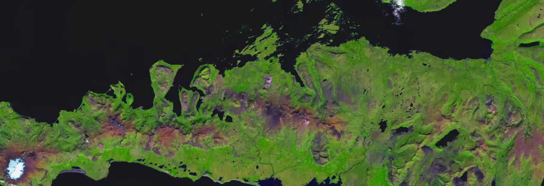
The Global Lakes and Wetlands Database (GLWD) version 2.0 is a harmonized global database providing detailed and updated mapping of lakes, rivers, and wetlands at a resolution of approximately 500 meters (15 arc-seconds). It builds upon the original GLWD by integrating new satellite and ground-based datasets, ensuring improved spatial and thematic consistency across the globe. The database covers a total global wetland area of approximately 18.2 million km², representing about 13.4% of the global land area excluding Antarctica.
Originally developed by Lehner and Döll in 2004, GLWD has become a foundational reference for diverse environmental applications over the decades. It has supported research and decision-making in areas such as water resource management, climate change impact assessments, biodiversity conservation, and ecosystem services evaluation.
GLWD v2.0 continues this legacy, serving as a critical reference for applications including hydrological and ecological modeling, biodiversity assessments, conservation planning, and studies on greenhouse gas emissions and human-environmental health.
Data Sources:
GLWD v2.0 harmonizes multiple data sources, including:
- Ramsar Convention on Wetlands
- HydroLAKES database
- Satellite remote sensing data
- National and regional wetland inventories
Wetland Classification
GLWD v2.0 classifies inland waters into 33 distinct categories, avoiding duplication and clearly distinguishing features based on:
- Permanence of water (permanent, intermittent, ephemeral)
- Hydrological conditions (inundated, saturated)
- Vegetation coverage (forested, non-forested)
- Salinity (freshwater, saline, brackish)
- Origin (natural, artificial)
- Landscape position and water source (riverine, lacustrine, palustrine, coastal/marine)
Example categories include freshwater lakes, saline lakes, reservoirs, rivers, marshes, swamps, coastal wetlands, mangroves, peatlands, salt marshes, river deltas, and rice paddies.
Data layers are provided as grids showing absolute area (hectares multiplied by 10) and relative coverage (percent per pixel), available both individually by wetland type and as combined grids indicating dominant wetland classes. GLWD v2.0 data is publicly accessible in ESRI Geodatabase and GeoTIFF formats via HydroSHEDS.org, covering latitudes from 56° South to 84° North and longitudes from 180° West to 180° East, excluding Antarctica. Distributed under a Creative Commons Attribution 4.0 International License, the dataset includes detailed technical documentation and a CSV legend file.
Funding for the development of GLWD v2.0 was provided by the World Wildlife Fund (WWF-US), The Nature Conservancy, and McGill University, with the initial concept formulated at a workshop coordinated by the Global Carbon Project.
Users are encouraged to properly cite GLWD v2.0 in any related publications or materials:
Citation:Lehner, B. et al. (2025). Mapping the world’s inland surface waters: an upgrade to the Global Lakes and Wetlands Database (GLWD v2). Earth System Science Data. DOI: 10.6084/m9.figshare.28519994.
Interactive Map
To celebrate the publication of the dataset, Confluvio developed a web app to enable users to explore the main wetland classification layer and visualize Ramsar sites together.

Access the web app at https://glwd-app.confluv.io